
This article follows the changes in thinking on the evolution of Chalk Downland Landscape. But firstly, it would be helpful to look at the ideas concerning the origin of landscape globally and then look at the peculiarities of Chalk Landscape.
The early model of landscape development.
James Hutton (1726 – 1797)the Father of modern Geology” presented his ideas to the Royal Society of Edinburgh 1785.
Amongst many ideas he presented, he recognized that there were continuous cycles of erosion, deposition and uplift, and that these have occurred throughout time and continue very slowly today. He called this the Geological Cycle.
He also noted that the physical and chemical processes which affected the rocks in the past, are the same as those operating today. This formed the basis of his Principle of Uniformitarianism. The key point of Uniformitarianism is that it should it be possible to understand the processes which formed ancient rocks by looking at the same processes operating comparable rocks today.
Charles Lyell (1797 – 1875) popularised Hutton’s Principle and coined the phrase “The present is the key to the past”.
William Davis (1850 – 1934)
At the end of the 19th century the American geomorphologist William Davis proposed a process of landscape development comprising three phases – uplift, erosion and stability which ended with a low relief erosion surface. This “Davisian Cycle” was used to explain landscape development for most of the 20th century.
A local example of its use was the speculation concerning the likely height of the Weald-Artois Anticline (“The Wealden Dome”) before it was eroded. This is an eroded upward fold stretching from the Sussex Weald to Artois in France. The presumption seems to have been that the uplifting dome retained its shape whilst erosion was somehow put on hold until the uplift was completed, and then the erosion phase started. This was the sequence described in the Davisian Cycle.
But Penck, a German, was not happy with this idea. He pointed out that the uplift and erosion processes would have been concurrent, and that it was the rate of uplift compared to the rate of erosion which determined the height of resulting relief.
So applying Penck’s idea to the Wealden Dome again, whether it ever reached its full height would have depended on to what extent erosion kept pace with uplift.
The Davis Cycle, as usually understood today, is as modified by Penck.
Wooldridge & Linton
(Wooldridge & Linton, 1939)
They used geomorphology to explain the history landscape during the Tertiary of south east England (The end of the Cretaceous, about 66mya, to beginning of the Ice Age, about 2.6mya.) They were working within the framework of the Davisian Cycle so they were looking to recognise flat surfaces which would represent the final erosion surfaces. They attributed most uplift in the Tertiary to an event which formed the Alps which they called the Alpine Storm dating from around 23 mya. The Wealden Dome was regarded as one of the outer ripples of this event.
If they were able to join separate summit surfaces in the same plane, they interpreted it as the remains of an erosion surface. They identified the remains of three such surfaces.
Discussion in the middle C20th was concerned with the timing and extent of these erosion phases. Known as the “Denudation Chronology”
These ideas fell out favour partly because their surfaces could only be recognised in south east England and so there was no widespread application.
Their methodology wasn’t very reliable, generally you can draw straight lines between any set of points, it doesn’t mean they’re related. But perhaps more significantly, there was no sedimentary evidence of the products of these erosion phases. This was facilitated by the results of new exploratory drilling for gas and oil in the North Sea which failed to find the expected sediments.
David Jones (Jones, 1999a, 1999b)
The effect of compression in the Weald from the Alpine Storm was downplayed.
Jones said that there had been direct uplift via a set of ancient deep seated vertical faults beneath the axis of the Wealden Dome. This uplift was concentrated along the centre of the Weald, controlled by the faults. It did not affect the flanking Chalk. The escarpments of the North & South Downs were not yet fully developed.
Uplift was now thought to be longer term with prominent pulses in early Palaeogene (just after the Cretaceous Chalk about 66 mya), early Neogene (the Alpine Storm about 23 mya) and the Pleistocene (the Ice Age began about 2.6 mya).
The recognition of the role of climate.
Gibbard & Lewin,
(Gibbard & Lewin, 2003) and reviewed in Whiteman & Haggart, (2018)
They looked at the effects of weathering on rocks as the climate cooled from warm temperate to tundra at the onset of the Ice Age. They concluded that it was the onset of a colder and unstable climate, rather than tectonic uplift and the resulting rejuvenation of rivers, which was the instigator of valley erosion, although it was agreed that uplift contributed.
Chemical weathering occurs in warm climates and is a very efficient type of weathering. It breaks down rock to fine grained residues which accumulate above a deeply buried surface, etched into the bedrock – an etchplanation surface. As in the tropics today, large slow flowing rivers meandered back and forth across a low relief plain easily removing the fine soils. Meanwhile Dense Tropical vegetation stabilized the land between the rivers, while they were meandering elsewhere, and preserved a low relief landscape.
Evidence for the presence of chemical weathering, prior to the Ice Age was found by examination of sediments which were newly accessible from boreholes in the North Sea and which originated from erosion of the Weald – Artois anticline. These sediments were fine grained, and in quantities consistent with products of chemical weathering. There was no evidence of the coarser sediments which would have resulted from erosion in a cool temperate climate, which were the conditions assumed to exist by Wooldridge & Linton, (1939).
The Clay-with-flints Formation found on the surface of the chalk had been recognised for some time as a deposit which was older than the recent drift deposits, probably pre – Ice Age. The re-assessment led to the understanding that it was a residual tropical soil, a chemical weathering deposit.
There was a re-evaluation of the Wooldridge and Linton erosion surfaces. The high-level surface that had been attributed to marine erosion by was re-interpreted as one of those deeply buried etchplanation surfaces, formed during a warmer pre-Ice Age climate, which had been exposed by removal of the overlying weathering debris.
It was also now thought that most of the Wealden Dome was chemically eroded in tropical conditions beneath a thick layer of fine-grained residue. And this was happening as it was being uplifted. It is suggested that up to 350m of chalk was removed, at depth beneath the tropical residual soils, during much of the Tertiary period. (Jones 1999).
So, referring to the Weald Dome, the dome profile never existed.
At the onset of the Ice Age there was a rapid drop in temperatures. The Ice Age is characterised by rapid fluctuations in temperature from cool Temperate (Interglacials) to Tundra (Glacials) and both interrupted by shorter lived fluctuations called “Stadials” and “Interstadials” but it was always colder than during the pre-Ice Age sub-Tropical to Tropical temperatures.
These new low temperatures prevented chemical weathering, which was replaced by mechanical weathering, which was mostly frost shattering in permafrost conditions.
Mechanical weathering is a less efficient method of breaking down rock. The debris from mechanical weathering are coarser than the chemical weathering products. They are sands, gravels, cobbles and boulders which were not easily removed.
The frequent changes in climate meant that ground moisture was frequently freezing and thawing encouraging frost shattering and which also has a particular effect on the chalk landscape as we will see.
This coarse debris needs high energy river flows to remove it, so the erosion was concentrated along the river valleys where high energy flows were generated during thaws.
The weathering debris on the land between the river valleys were not eroded the to the same extent as along the river valleys. This allowed the development of a more prominent relief as the rivers removed weathering products from between the valleys leaving debris between the rivers to accumulate, resulting in the typical hills-and-valley relief typical of Temperate Climate.
Gibbard & Lewin concluded that “Climate, and not tectonic uplift, is the primary drive on fluvial incision in the Pleistocene.”
Summary of current views on regional influences on landscape
- Both uplift and climate played a part
- Uplift is now thought to have occurred as a series of phases, active since the later part of the Cretaceous, not just the “Alpine Storm”
- The most recent uplift phase is now believed to have started at the Pleistocene Ice Age about, 2.6 million years ago, and has intensified during the middle to late Ice Age.
- The Ice Age drop in temperatures promoted erosional processes which facilitated a more pronounced relief.
Chalk Downland
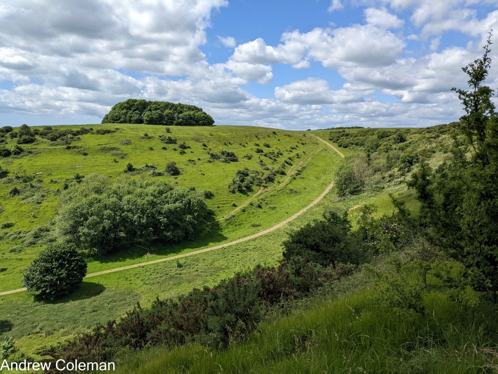
Photo 1. Coombe on the east side of Tolsford Hill (viewed from NGR TR 1655 3862, ///cheek.trifling.sock).
The standout features of Chalk Downland are the dry valleys (Photo 1).
This next section looks at what the dry valleys are, then looks at why they caused problems, and then the ideas that were put forward to resolve them.
Dry Valleys in Chalk
Rivers in chalk valleys are supplied directly from the Water Table – that is through the riverbed (although run-off can occur after heavy rainfall)
They become dry valleys when the water table is below the valley floor.
In normal valleys, in lowland areas, the relief becomes less marked as you travel upstream and it’s often difficult to trace the source of its stream when it runs over increasing flatter ground.
In dry valleys in chalk, the relief at the head of the valley is pronounced, often more so than downstream.
So, what’s the problem with dry valleys in Chalk? Geologists and geomorphologists had long been interested in the paradox of the deep, steep sided, dry valleys in chalk. The steep slopes at the head of these valleys would normally be attributed to erosion by large volumes of water and a high energy flow, typically from Ice Melt. But Chalk is permeable, so how could any surface flow have been possible?
Applying the Principle of Uniformity – The present is the key to the past – what conditions might have allowed water to flow in dry chalk valleys in the past?
Flow could have occurred if –
- Precipitation was greater in the past
- Uplift has since raised the valleys above the water table
- Sea level has fallen, lowering the water table
- A combination of all three
The Victorians’ ideas.
Victorian geologists were interested in the dry valleys in chalk paradox.
Clement Reid (Reid, 1887) was working for the Geological Survey on the dry valleys in the dip (south-facing) slope of The South Downs, a similar geological environment to north slope of The North Downs.
Reid had difficulty in attributing the shape of these dry valleys to erosion by streams. He was puzzled by the steep slope at the head of these valleys. He could not envisage how water could have issued here, where the slope of the bottom of the valley exceeded any conceivable slope of “the plane of saturation” (water table) in the chalk, which he stated “never exceeds, if it reaches, 60 feet in a mile” in contrast to the steepest valley slopes which reached up to “500 feet in the mile”. He noted that even after the heaviest rainfall, no streams flowed from these steep head-slopes.
Reid did acknowledge that those rivers which cut through the South Downs escarpment, and those occupying the lower, flatter, reaches of the larger coombes were controlled by the local water table. They had cut down into the valley floor following the water table in response to uplift phases and left river terraces as evidence of each erosional stage. The absence of such terraces in the steep sided coombes suggested to him that those had not been formed by erosion of rivers cutting down in response to the falling water table. (See below for more on River Terraces)
Reid looked at the sediments on the dip slopes of the South Downs as a means of trying to understand the processes which had formed them. He found widespread sheets of sediment (known locally as “Coombe Rock”) which extended across flat land, some distance away from the dry valleys in the escarpment. He described the Coombe Rock as “Flints, battered, but not rolled, and embedded in a matrix of chalky paste and pieces of chalk.”
He saw that these deposits did not show any of the characteristics of a sediment laid down by glaciers, by the sea, or by rivers; he found no striated stones, which would have indicated a glacial origin; he found no rolled stones, which would have indicated erosion by the sea or rivers, he found no sedimentary bedding structures characteristic of sediments deposited under water. Neither could he find any remains of aquatic flora or fauna which would have been expected if water was present for any length of time.
He did find the remains of amphibious fauna typical of those living in marshy environments. He also noted that the Coombe Rock was characterised by inclusions of intact chalk, a weak rock which ought not to have survived transportation and deposition by flowing water.
Addressing a meeting of the Geological Society in 1887, when referring to the typical rolling outlines of the chalk downland, Reid remarked:
“But, perhaps because so familiar, it does not at first strike one that these outlines point to conditions which have now entirely passed away.” (Reid, 1887)
He proposed that those conditions had existed in the Pleistocene (Ice Age) during periods of a Tundra climate and which disappeared with each ice retreat. Permafrost (ground which is defined as moist ground which is below freezing for more than two years) would have been the norm. When such Chalk froze, it formed an impermeable barrier, so that any summer rainfall or snow melt would have flowed over, not into, the chalk as brief but vigorous meltwater torrents. This run-off would have easily eroded the already frost shattered still frozen chalk. He suggested that the chalk remained frozen during transportation, which would explain why individual blocks remained intact when deposited. He proposed that this was the process which formed the deep, steep sided valleys and was the origin of the coombe deposits.
The phenomenon of torrential flows caused by spring thaws running over frozen ground was widely recognised at that time. Dr Hinde, a delegate to the meeting at which Reid presented his paper, was reported to have responded that in Canada,
“….a greater amount of denudation is effected in 24 hours, at the sudden break-up of frost in spring, than takes place in the whole of the rest of the year.”
In the same year that Clement Reid presented his paper, The Rev. E. Maule-Cole, the vicar of Wetwang, in the East Riding of Yorkshire, made the following observation following a particularly cold winter on the Yorkshire Wolds:
“The month of January, 1887, will long be remembered on the Chalk Wolds of East Yorkshire, as presenting one of the most curious sights ever witnessed. A succession of frosts had frozen the bare ground so hard, that no rain could penetrate. What little rain fell was quickly converted into ice. On a sudden came a rapid thaw; and in a few hours the dale bottoms were converted into roaring torrents, in some cases 3 feet deep. The ground was still frozen hard underneath. The melting snow could not penetrate, and so rivers ran in dry places.” (Maule-Cole Rev. E., 1887).
Reid made the point that whilst the processes forming the Tundra landscape are available for inspection in Siberia and North America, those regions have been repeatedly glaciated so that any younger softer rocks, comparable with the chalk, have been removed leaving only the ancient hard bedrock. Consequently, there are no opportunities to study the processes of weathering and erosion on a weak permeable rock such as chalk in a Tundra climate. In effect, he was demonstrating that Hutton’s Principle cannot be applied if there is currently nowhere on earth with conditions comparable with those in the past.
Reid’s explanation invoking the effect of ice melt torrents may have explained the steep sides of the coombes but it did not explain their steep head walls. Interest in the paradox of chalk valleys continued into the early 20th century.
Osborne White (1924) suggested that, when referring to the south facing coombes in the dip slope of the South Downs above Brighton,
“…the sloughing-off of the superficial portions of the Chalk….affected the terminal southern slopes, as well as the lateral slopes, of the downland ridges.” (by terminal southern slopes he meant the south facing head-slopes) and also, when referring to a section near Black Rock Brighton, that…
“the bulk of the Coombe Rock there came down the seaward slope of Red Hill in a pasty condition….”
Here he was describing a type of mass movement which occurs in a fine-grained soil with a sufficiently high water content to make it behave as a viscous fluid (solifluction or soil flow). Wet frost-shattered chalk would take on these characteristics. He was also making the point, which Reid had not, that this process would affect the sides and head-slopes equally. So, this supplied the missing explanation of the origin of the steep head-slopes which Reid had recognised but had not fully explained.
A small diversion into technicalities:
A soliflucted soil keeps moving until the water held within the matrix drains away through the base, when it reverts to behaving like a solid.
But when the movement of the pasty mass occurs in permafrost conditions its movement is called gelifluction (or ice flow). This distinction between solifluction and gelifluction isn’t just pedantic semantics, the mechanisms differ and explains their different behaviours.
A geliflucted soil contains ice in frozen lumps of chalk or as free ice. As the ice melts, it replenishes the supply of water within the matrix. This prolongs its fluid state, allowing it to flow longer and further than it would have done if it was just relying on its initial charge of water, as is the case in a soliflucted mass. This explains the large distances that the fans of chalk debris were able to move in permafrost conditions.
The mid-century interest in melt water floods.
Despite the early C20th understanding of the significance of solifluction, ideas in the mid-century seem to have been concerned with meltwater floods. There was a lot of interest in the evidence available by studying River Terrace Gravels.
River terraces are the remains of valley-floor sediments left on the sides of valleys as a river enters a new cutting down phase. There are five terraces recognised in the Thames valley basin which includes the Medway and Stour in Kent. They provide a sedimentary record of the nature of the flows which deposited them and their dates for each down cutting phase.
They can also be dated using palaeontological and archaeological methods. These dates match with the Marine Isotope Stages (MIS dates) of Glacial and Interglacial stages and occasionally the shorter Stadials and Interstadials, so these terraces are a record of ice melt torrents. (MIS dates are derived from the ratio of Oxygen 18 isotopes recovered from cores in the seabed which vary with the sea temperature. It’s a proxy, not a direct measure of land temperature – there is now discussion about how globally valid these MIS dates are)
Members of a Geologists’ Association visit, during Whitsun 1925, looked at River Terrace Deposits exposed in gravel pits the Stour valley, at Sturry, near Canterbury. They revealed:
“…masses of Woolwich Clay [older] rested at high angles on even-bedded, laminated brick-earth [younger] and at the point of contact the laminae were broken, bent or twisted.” (Dewey et al., 1925).
The authors used this strange occurrence to demonstrate that the normally malleable clay must have been ripped up from the riverbed in a solid, frozen, condition to have survived transportation intact, and that a high energy water flow was involved.
The Geological Survey Memoir for Canterbury and Folkestone (Smart et al 1966) include the following (unusually imaginative) description of what one of these meltwater torrents might have looked like:
“…the picture of conditions…is thought to be one of large quantities of rapidly flowing water moving, besides their load of chalk, sand and gravel, blocks of floating and rolling ice charged with debris. In most cases debris must have choked the water courses and become piled into aggradations of debris, with the higher levels channelling into the lower and overstepping them to rest upon solid strata.” (Smart et al., 1966).
This description of conditions was referring to the Great Stour valley but similar floods on a smaller scale would have occurred in the tributary valleys, for example the lower part of the Elham valley, as evidenced by the River Terrace Deposits, which are shown on the geological maps, on the upper sides of the valley from Barham downstream and also mentioned in Smart et al. (1966).
These “torrent bedded” deposits could be several metres thick, so rather than being interpreted as the result of seasonal thaws it was concluded that they were the result of large-scale thawing at the end of each glaciation and, because they comprised deposits of various ages, they indicated that there were several glacial retreats.
The significance of this was that it placed the formation of chalk downland landscape to within the Ice Age, before the last ice melt and the formation of the deep dry valleys described by Read and Osborne White. There seems to have been a tendency to attribute the formation of all Chalk downland valleys to glacial meltwater torrents, even those steep sided coombes which the Victorians had difficulty in attributing to flowing water.
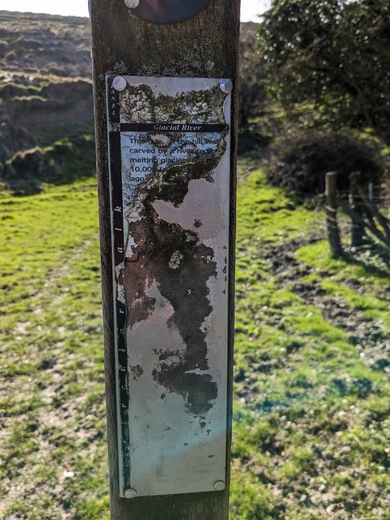
Photo 2. An information Post on the North Downs Way (TR 14272 39617 ///barbarian.stays.cattle).
There is a tangible reminder of the idea that meltwater floods were responsible eroding the dry valleys in the form of an old but still legible information post on the North Downs Way (Photo 2). It reads “This Gully…the hill was carved by a river fed by melting glaciers 10,000…ago” It attributes the origin of a small gully above Postling to a glacial meltwater river.
Solifluction was acknowledged but not considered to be sufficient to erode the large volumes necessary to form the deep chalk valleys.
Before the end of the century, it was thought that uplift forming the North and South Downs escarpments had been completed before the Ice Age started. So leading into the Ice Age, the topography was much as it is today.
The steep head slopes were explained by spring sapping – This is the process by which a spring cuts into the base of a slope and extends the valley into the escarpment. When such streams intercepted existing streams, they were said to have “captured” them, diverting their water into the capturing stream.
(Smart et al., 1966) include many examples of features with origins explained within this framework.
Reviving earlier ideas.
The Devil’s Kneading Trough coombe.
The Devil’s Kneading Trough coombe is in the scarp slope of the downs above the village of Brook (Photo). It has unusually regular sides, even by coombe standards, and its head is double ended giving it a fish tail shape. (The abrupt changes of slope are thought to have been accentuated by Iron Age ploughing adjacent to its top edge and along its base).
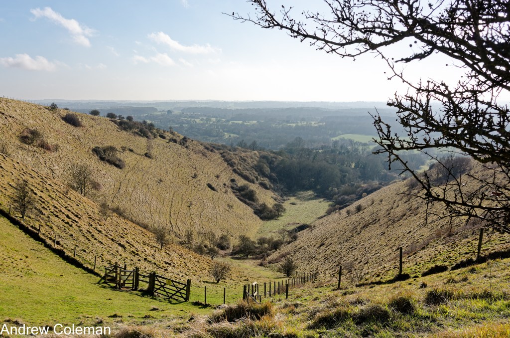
Photo 3. The Devil’s Kneading Trough above Brook (NGR TR 077 453, ///origins.wordplay.witty).
In 1964 Kerney, Brown & Chandler (Kerney et al., 1964) presented their findings of a comprehensive study of the sediments found around the Devil’s Kneading Trough near Wye.
They came to similar conclusions to Reid in 1887, except they also found sedimentary evidence of water flow. This is not surprising as Reid’s coombe was in the top part of the chalk, well above the modern water table, whereas this coombe is at the base of the chalk sitting on the Gault clay where springs still issue.
They found a chalk debris fan, similar to Reid’s Coombe Rock, spread out in front of the escarpment up to a mile away from the coombe and up to 6m thick.
They estimated that the volume of this fan, as they wrote, “would go far towards eliminating the cavity in the escarpment formed by the Devil’s Kneading Trough, whence most of it must have come.” and they pointed out that their estimate of volume was an under-estimate as it ignored chalk which was carried off in suspension and solution.
But the important development was that they were able to use Carbon 14 isotope dating to provide dates for the sediments eroded from the coombe.
They found by dating the sediments eroded from the coombe and deposited in front of it, that most of it dated from a 500-year period between 8,800 and 8,300 BCE. This was revised by later analysis to roughly 10,100 – 9,700 BCE which coincides with the last interruption of the ice retreat (the Loch Lomond Stadial). They showed that at this time, temperatures were hovering around freezing with a humid atmosphere. These conditions would have allowed regular freezing and thawing which are ideal conditions for inducing solifluction (gelifluction).
The relative contribution of erosion by water or by mass movement to the formation of chalk coombes seems to be the subject of current discussions. But it is accepted that the weathering occurred in “conditions which have now entirely passed away” and that chalk downland is a recently formed tundra landscape clad in temperate vegetation.
A suggested summary of current thinking –
Firstly the role of uplift
Uplift occurred in the Pleistocene, and accelerated towards the end
The chalk escarpments developed, or at least became more prominent, during the Ice Age
And Climate
The development of relief was instigated by the Ice Age temperature drop, promoting mechanical erosion
Temperature fluctuations have become more marked since 900,000 years ago, and the length of the glaciation cycles have increased from 40 to 100 thousand years.
Those increased temperature fluctuations within the glacial period, provided more opportunity for conditions conducive to Mass Movement by gelifluction, when temperatures were hovering either side of freezing.
Mass movement by gelifluction played a significant part in erosion
Andrew Coleman
Rev. 24/02/2026
References:
Dewey, H., Wooldridge, S. W., Cornes, H. W., & Brown, E. E. S. (1925). The geology of the Canterbury District. Proceedings of the Geologists’ Association, 36(3), 257–290. https://doi.org/10.1016/S0016-7878(25)80010-5
Gibbard, P. L., & Lewin, & J. (2003). The history of the major rivers of southern Britain during the Tertiary. In Journal of the Geological Society (Vol. 160). http://jgs.lyellcollection.org/
Jones, D. K. C. (a). (1999a). Evolving Models of the Tertiary evolutionary geomorphology of southern England, with special reference to the Chalklands. In Ulift Erosion and Stability: Perspectives on Long-term Landscape development. (Vol. 162, pp. 1–23). Geological Society, London Special Publications.
Jones, D. K. C. (b). (1999b). On the uplift and denudation of the Weald (B. J. Smith, W. B. Whalley, & P. A. Warke, Eds.; SP 162, pp. 25–43). Geological Society. http://sp.lyellcollection.org/
Kerney, M. P., Brown, E. H., & Chandler, T. J. (1964). The Late-Glacial and Post-Glacial History of the Chalk Escarpment near Brook, Kent. Philosophical Transactions Of The Royal Society of London., 248(745), 135–204.
Maule-Cole Rev. E. (1887). Note on Dry Valleys in Chalk. Proceedings of the Yorkshire Geological and Polytechnic Society., 9, 343–346.
Osborne White, H. J. (1924). The geology of the country near Brighton & Worthing.
Reid, C. (1887). On the origin of Dry Chalk Valleys and of Coombe Rock. Quarterly Journal of the Geological Society, 43, 364–373.
Smart, J. G. O., Bisson, G., & Worssam, B. C. (1966). Geology of the Country around Canterbury and Folkestone. Her Majesty’s Stationery Office.
Whiteman, C. A., & Haggart, B. A. (2018). Chalk Landforms of Southern England and Quaternary Landscape Development. Proceedings of the Geologists’ Association. https://doi.org/10.1016/j.pgeola.2018.05.002
Wooldridge, S. W., & Linton, D. L. (1939). Structure, Surface and Drainage in South-east England. Institute of British Geographers.
