The next part of the RSW climbs to the top of Tolsford Hill which is the highest named hill in East Kent with an elevation of 181m AOD (above sea-level). The route passes onto the Chalk of the North Downs.
The British Geological Survey (Aldiss et al., 2012) has published a document showing how to recognise the boundaries of the Chalk Formations by noting the nature of the change of slope at their boundaries and the type of “Brash” (stones brought to the surface by weathering and agriculture). That document includes the advice that, in order to identify a change of slope, it may be necessary to lay prone and look along the slope at ground level, which presumably would require several changes of position before succeeding. This is probably above and beyond the enthusiasm of the average walker following the RSW, so the Formation boundaries will only be noted if the changes in slope are easily seen.
As described in the previous section, the Chalk begins at the increase in gradient on the slope up to Etchinghill. The lowest part of the Chalk Group is the West Melbury Marly Chalk Formation and is one of two formations comprising the Grey Chalk Subgroup. It underlies the village of Etchinghill with a finger extending northwards along the East Brook stream towards North Lyminge.
The point where the route crosses the road on the south side of Etchinghill is also the boundary between the West Melbury Marly Chalk Formation and the overlying Zig Zag Chalk Formation (named after a former exposure in road called Zig Zag Hill near Shaftsbury) and this is the top part of the Grey Chalk Subgroup. The Zig Zag Chalk forms the bedrock beneath most of Tolsford Hill and the outcrop extends northwards along the bottom of the Elham Valley beyond Lyminge. It is mostly firm, pale grey to off-white blocky chalk with a lower part containing alternate layers of marls (clayey chalk) and firm white chalk. It can be regarded as a transition between the underlying grey clayey, sandy chalk and the overlying typical white chalk.
At the end of the steep climb near the small metal gate, the reduction in gradient coincides with the mapped boundary between the Zig Zag Chalk and the overlying Holywell Nodular Chalk Formation which underlies the top of Tolsford Hill. The latter is the lowest formation in the White Chalk Subgroup which forms the majority of the Chalk Group and comprises seven formations, although the two highest are missing in east Kent. The complete White Chalk sequence spans the period from about 94 to 66 million years ago.
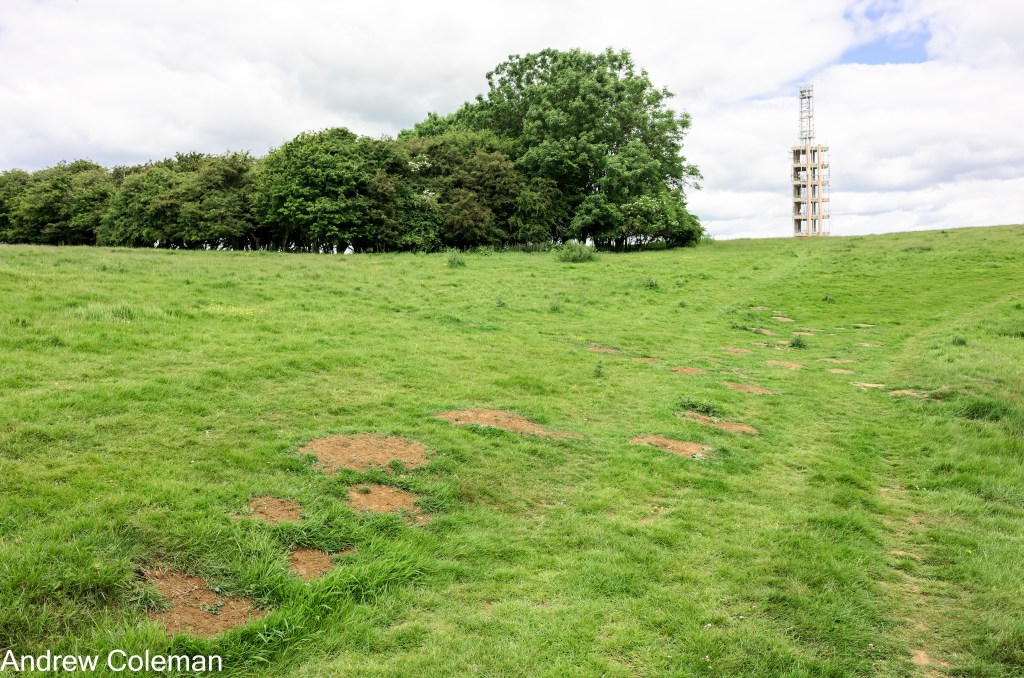
Beyond the metal gate the route follows the northern edge of a typical chalk coombe (a steep sided dry valley with a steep headwall). Many of the chalk valleys follow fault lines, and the abrupt change in direction to the south-east in this coombe coincides with the mapped position of a fault running north-west to south-east (Photo 1.)

A view south westward from the top of Tolsford Hill allows you to see the eastern most part of the core of the eroded anticline, mentioned in the previous section. This is the sea cliff at Fairlight visible beyond the Dungeness peninsular.
Tolsford Hill, and many of the tops of the North Downs, is capped by the Clay-with-flints Formation. The clay encourages the development of a topsoil and more substantial vegetation than the grass found on those parts of the downs directly underlain by chalk. This distinguishes more tree covered North Downs from the grasslands of the South Downs where the Clay-with-flints deposit is much less abundant.
The British Geological Survey includes the Clay-with-flints in the “Superficial deposits” category, but it is much older than the other superficial deposits which date from the Ice Age. The Survey places its formation to between 23 million and 2.6 million years ago, in its Lexicon of Named Rock Units, and on its digital maps as between 23.03 million to 11.8 thousand years ago (the end of the last glaciation). The warmer climate in those times induced chemical weathering of the rocks. The Clay-with-flints is a residual weathering product of that process.
The normal Clay-with-flints Formation is a stiff, red brown to chocolate brown sandy clay with abundant flint nodules. At the base of the deposit, the sand content of the clay disappears and is a dark brown to black clay with black stained flint nodules.
On Tolsford Hill, and elsewhere along the crest of the escarpment between Folkestone and Wye, there are isolated deposits of Sand in Clay-with-flints. This comprises reddish brown clay or sandy clay with abundant flint pebbles and iron-rich sandstone. (See the entry for Clay-with-flints Formation in “Rock types encountered along the RSW” and “Local Sources of Ironstone” for more information on this sandy deposit). An example can be seen on the surface beyond the large wooden gate near the top of the hill (Photo 2) and thrown up in mole hills near around the top of the coombe (Photo 3).

The descent from Tolsford Hill marks the beginning of the next section of the RSW, The Elham Valley. As you descend, note the distinctive broad fan shape of the top of the valley.
Continued in the section called “The Elham Valley”.
Andrew Coleman
Rev. 01/01/2025
Reference:
Aldiss, D. T., Farrant, A. R., & Hopson, P. M. (2012). Geological mapping of the Late Cretaceous Chalk Group of southern England: A specialised application of landform interpretation. Proceedings of the Geologists’ Association, 123(5), 728–741. https://doi.org/10.1016/j.pgeola.2012.06.005
