This section of the Royal Saxon Way runs from the Risborough Barracks, past the Channel Tunnel approach bridge, to the foot of the North Downs at Etchinghill.
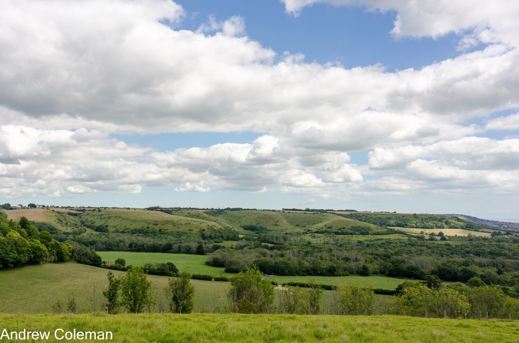
A view looking northwest from the junction of North Road, Pond Hill Road and West Road, (TR 1933 3590, ///pollution.smilings.ruins) allows you to appreciate the geological structure which defines the topography of Kent and Sussex. You are standing on top of the Greensand Ridge, underlain by the sands and sandstones of the Folkestone Formation. This is one of two ridges flanking the north side of The Weald – Artois Anticline, described in the introduction. You can see the second ridge, the North Downs, to the north in the distance. Here, in east Kent, the North Downs are the higher of the two ridges at about 180m AOD (above sea-level) whereas the Greensand Ridge is about 100m AOD. Further to the west, the Greensand Ridge becomes higher than the North Downs, at 294m AOD at Leith Hill, which is the highest remaining part of the dome.
There is also a secondary escarpment of limited extent at the top of the Folkestone Formation which you can see in the middle distance. This escarpment is formed from a locally developed sandstone, “Folkestone Stone” which is present east of Stanford TR 130 380, (Smart et al., 1966). Here the outcrop is obscured beneath a heavily wooded slope incised with short steep sided valleys, but you can see the Folkestone Stone exposed in the Leas Cliff further east in Folkestone.
After crossing one of these valleys, the Horn Street valley, you arrive at St Martin’s Church on St Martin’s Plain. The path eventually leads to the edge of the Folkestone Stone escarpment and descends steeply through woodland. Even when wet, it is firm under foot as you walk down this slope, a benefit of the underlying well drained sand and sandstone of the Folkestone Formation.
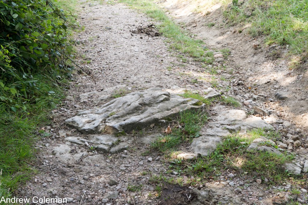
On emerging from the wood at the foot of the slope, there is a boulder of Folkestone Stone near the footpath sign. These boulders are known as “Doggers” and this one probably originated from the sandstone outcrop further up slope (Photo 1).

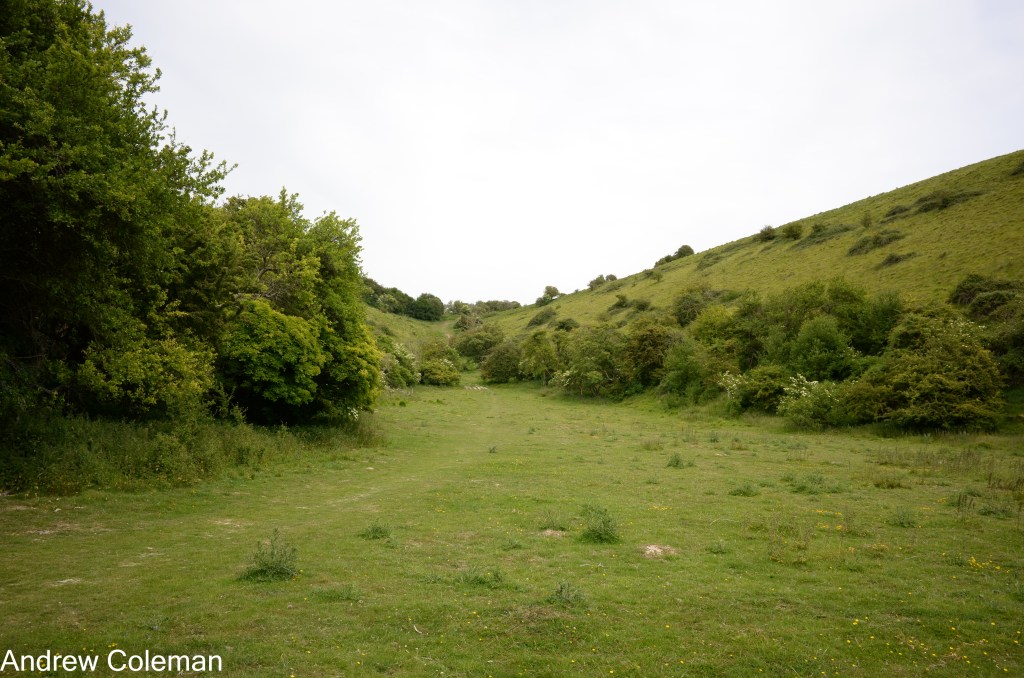
The route continues by crossing the upper part of the Seabrook Stream valley. The south western side of the valley is mapped as Landslip and a small strip along the bottom of the valley is mapped as peat. It is unusual to find peat in an elevated position in southern England but several of the adjacent valleys contain tracts of this deposit. This example no longer supports typical peat bog vegetation as it has been colonised by trees along the stream but digging your heel into the ground soon reveals the peat.
The path climbs the side of the valley towards Dibgate Camp, returning to the top of the plateau. Near the top of the path there is a further example of Folkestone Stone (Photo 2).
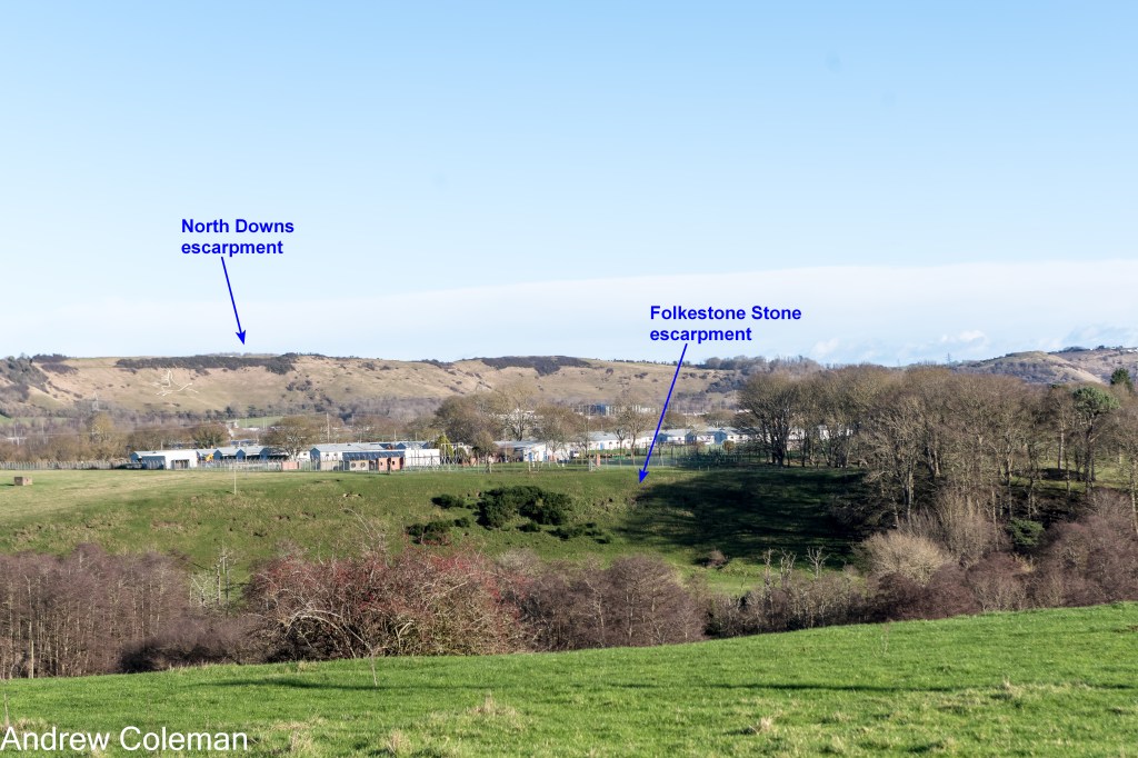
After leaving Dibgate Camp the road descends again into the Seabrook Stream valley further upstream. From the top of the descent, you can see the secondary Folkestone Stone escarpment and beyond that, the escarpment of the Chalk Group forming the North Downs (Photo 3).
After crossing the Seabrook Stream northwards the route climbs past the former Newington Quarry on the west side of the path and to the south of the railway (Photo 4). Smart et al., (1966) mention the remains of several old quarries along the Folkestone Stone escarpment. They refer to this one as “a large disused sand pit” (their O.S. Grid ref. TR 180 369).
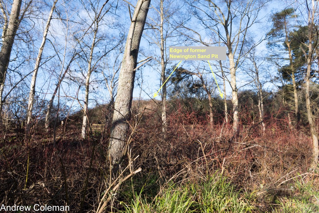
They also report that this sand pit originally contained “massive doggers of limestone and bands of chert, seen for 15 feet” (4.5m) near the top of the quarry face, so it is possible that this quarry was a source of Folkestone Stone used for building stone as well as sand. An early record of a quarry here appears on the 6”: 1 mile, sheet LXXIV, surveyed 1872. Current O.S. maps show no indication of a quarry, but aerial imagery between 1990 and 2003 (available via Google Earth Pro) shows reclamation and gradual recovery of vegetation. The shape of the bank visible from the route suggests that the ground level has been raised by the addition of fill.
The Memoir also mentions a former sand pit at Sandling Junction, further west at TR 147 371, in which they describe a 1ft (0.3m) thick bed of “reddish brown sandstone”. There is also reference to ironstone in this quarry, follow the links below for further information.
Deviations:
Follow this link to other Local sources of Ironstone.
Follow this link to A large unmapped quarry with Folkestone Stone near Newington.
The route continues to the North Downs via Newington to Etchinghill, passing over rocks dating from the youngest part of the Lower Cretaceous Epoch. After leaving Newington, the path runs parallel to Newington Road towards Peene. Note the embankment on the east side of the path which was built to provide a level formation for the Channel Tunnel terminal using sand dredged locally from the sea bed. The underlying geology is still the top of the Folkestone Formation but as the route approaches the Elham Valley Railway Museum, it passes (without any topographic effect) onto the Gault Formation, which is the only representative of the Selborne Group in this region.
The Gault is a shallow marine deposit comprising dark grey clay and mudstone, about 113 million years to 101 million years old. Gault clay has been used locally for the manufacture of bricks after the addition of sand (Smart et al. 1966 p298). The outcrop forms a poorly defined depression running along the foot of the Downs extending westwards into Surrey, known as the Vale of Holmesdale. It tends to induce a rather damp environment as a consequence of the poor drainage into the impermeable clay.
The route turns north west along the embankment of the former Elham Valley Railway just north of the railway museum. Good views of the North Downs escarpment may be had through the trees (at least in winter when there are no leaves). This is the first encounter with the Chalk Group which comprises the whole of the Upper Cretaceous Epoch, but while passing, note the “Coombes” the distinctive short, steep-sided valleys with steep head slopes and often with unnatural-looking flat bottoms (Photos. 5 and 6 – the location of the second photo is accessible via a short eastward diversion along the North Downs Way).
The chalk is permeable and hosts one of the most important aquifers in southern England. The water held in the chalk is prevented from soaking downward by the underlying impermeable Gault and, to a lesser extent, by the more clayey parts of the lower part of the chalk. This gives rise to springs near its base (see the end of this section for more details).
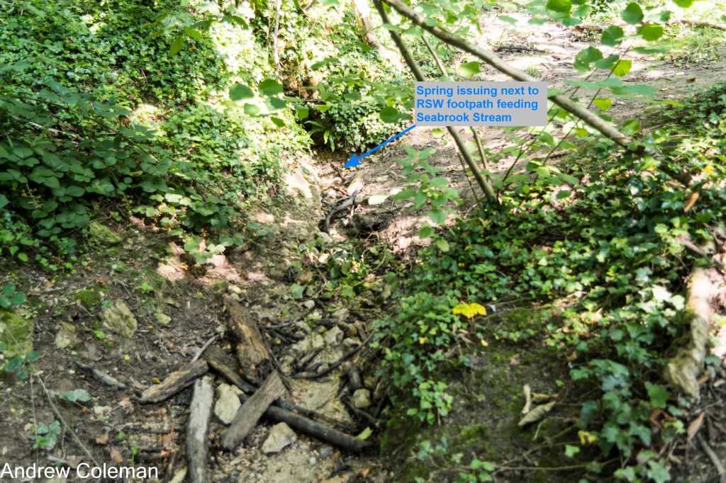
After descending from the old railway embankment, the route follows a wooded section close to the spring line on top of the Gault and crosses the Seabrook Stream and several of its tributaries including a spring adjacent to the path (Photo 7).
Where the route emerges from the woodland the ground begins to rise towards Etchinghill. There is a slight but noticeable increase in gradient about halfway up the slope which marks a change in the geology from the clay of the Gault Formation to the Grey Chalk Subgroup which forms the lower part of the Chalk Group. This dates from about 101 to 94 million years ago (Photo 8).

The Grey Chalk comprises two Formations; the West Melbury Marly Chalk at the base and the overlying Zig Zag Chalk. The West Melbury Marly Chalk is a buff, grey and off-white, soft, marly chalk with layers of hard grey limestone (Marl is a chalky clay). The rock in the bottom few metres is recognised as a separate unit called the Glauconitic (greenish) Marl Member which is chalky sand and sandy silty chalk with phosphatic nodules. So, the base of the Chalk has a variable lithology, from limestone, to sand, to clay, and this results in a variable permeability. The combination of permeable and impermeable layers in the base of the Chalk can cause springs to issue from slopes well above the main Chalk and Gault boundary.
The main spring line on top of the Gault clay produces damp if not marshy conditions. This is reflected in the vegetation which changes from grass with tussocks of sedge, characteristic of damp soils, to grassland (Photo 9).
A deviation: Follow this link to Springs for more on the local springs.

The route onto the Chalk is continued in the section called “Tolsford Hill”.
Andrew Coleman
Rev. 01/01/2025
Reference:
Smart, J. G. O., Bisson, G., & Worssam, B. C. (1966). Geology of the Country around Canterbury and Folkestone. Her Majesty’s Stationery Office.
