
One of the objectives of a Geopark is to highlight the influence of geology on the development of the local culture. This section lists the ores and minerals found in the Kent Downs National Landscape area of the Cross-Channel Geopark and outlines their historical development as a resource.
There are six resources outlined in this section. Not all the locations are entirely within the Geopark.
Ironstone as a building material and iron ore.
Sand as a construction material.
Gravel as a construction material.
Clay as a building material.
Flints as a building material and for ancient tools and weapons.
Coal The last Kent colliery closed in 1989. The first colliery was at Dover, within the Geopark, but was short-lived and not commercially viable. The four successful collieries were outside the Geopark boundary. They are listed here as the collieries have influenced the local culture.
Iron ore and Iron workings
Evidence of iron smelting and smithing was uncovered during recent archaeological investigations at Tayne Field in Lyminge on the site of a significant 7th century Anglo Saxon settlement, which was most probably a royal palace (Thomas et al., 2017, Ref.1.)
Sandstone with a high iron content and a characteristic high density is found as a minor constituent in the external stone rubble walls of some of the churches along the Royal Saxon Way, in and near the Elham Valley.
These occurrences led to speculation concerning the sources of ironstone used for both smelting and as a building stone.
Smelting – development and terminology.
Smelting is the process by which metal is extracted from iron-bearing material in the ground, using heat. Iron smelting was carried out in a type of furnace called a “bloomery” from the Iron Age to mediaeval times.
Bloomeries were an improvement on the earlier open pits as they enabled air to be forced into the furnace through “tuyeres” using bellows. This allowed a greater volume of ore to be heated to the required temperature. However, that temperature was still insufficient to melt the resulting iron which formed an aggregated lump of iron and non-metallic solids (slag) called “bloom”. This was repeatedly hammered while still red hot to remove the impurities. The resulting product was malleable “wrought iron” which could be shaped to form sheets or billets. These were further worked using heat in a smithy to produce a wide variety of wrought iron objects.
Sometimes parts of the bloomery furnace became hot enough to melt the iron which drained to the bottom of the furnace and solidified as “pig iron”. This was not malleable and so was discarded.
- Thomas, Gabor., Knox, Alexandra., & Hamerow, Helena. (2017). Anglo-Saxon studies in archaeology and history. 20, Early medieval monasticism in the North Sea zone : proceedings of a conference held to celebrate the conclusion of the Lyminge excavations 2008-15. Oxford University School of Archaeology.
Sources of iron ore for smelting sites on the Downs.
Weald Clay Formation
Smart et al. (1966, Ref. 2) – “The Memoir” – reports the presence of ironstone bands and nodules in various Weald Clay outcrops, including one just south of Horn Street (p64). These ores are low grade and would have required transporting large volumes to produce useable quantities of iron. Transportation from the Weald over the Greensand Ridge and then over the North Downs escarpment would seem unlikely. The Saxon smelting site at Lyminge, for example, is more than 20km from the Wealden ironstone which suggests that there were other sources of iron ore available locally.
2. Smart, J. G. O., Bisson, G., & Worssam, B. C. (1966). Geology of the Country around Canterbury and Folkestone. Her Majesty’s Stationery Office.
Sand In Clay With Flints
Iron rich sandstone occurs in a deposit listed in the British Geological Survey’s (BGS) Lexicon of Named Rock Units as ‘Sand In Clay With Flints’. It is given Index Level status within the Clay-with-flints Formation (see the entry in Rock types along the RSW).
The Sand In Clay With Flints is found in discrete outcrops overlying the Chalk, typically at an elevation of 150-180m above O.D., along the top of the North Downs between Hastingleigh and Capel-le-Ferne. Several outcrops are shown on the 1:50,000 BGS paper maps on the high ground around the upper Elham Valley within 3km of Lyminge and Elham. Larger outcrops occur near Rhodes Minnis, Acrise and Paddlesworth.
The Memoir mentions the existence of seams of ‘iron-sandstone’ in blocks, ‘3-4 feet wide by 1 foot thick’ in the Sand In Clay With Flints in the Paddlesworth deposit.
Iron smelting was a well-established industry in Wye before and during the Roman occupation, with two Roman bloomery sites, an ironmaster’s house, and a stockyard identified in the village. These bloomeries used ore obtained from ‘mine-pits’ above the village on Wye Downs (TR072467) and at Staple Lees (TR090455) near Hastingleigh. Reference to the paper editions of the 1:50,000 mapping published by the BGS shows these sources of iron ore are co-incident with outcrops of the Sand In Clay With Flints.
There are several references in The Memoir to small quarries on the Clay-with-flints Formation on the top of the North Downs (and close to the smelting site at Lyminge). The identity of the material excavated is not always made clear, but there is an example near the Royal Saxon Way on Tolsford Hill which is described in The Memoir as a partly overgrown excavation and which included ‘occasional blocks of fine-grained dark brown ferruginous sandstone’. Photo 1 shows the likely location of that excavation, which is about 2 km south of Lyminge.
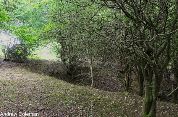
Photo 1. The likely excavation referred to in the memoir at National Grid Reference TR 161 385, ///novelist.frown.bluff
Further afield, The Memoir mentions an extensively dug deposit of Sand In Clay With Flints half a mile north of Sole Street (TR 097 502, ///sharper.verifying.warp) littered with ironstone fragments and iron-slag clearly indicating smelting there. This illustrates the close proximity of the smelting site to the source of ore, which makes sense as it minimises the transportation effort required.
The Kent County Council (KCC) Heritage Environment Records (HER) include locations of possible ironstone pits. The Heritage Maps show a small cluster on Tolsworth Hill at (TR 156382) & (TR 15853840) which are to the west of the excavation site in Photo 1. The second location also showed evidence of smelting.
Evidence of bloomery sites is recorded near Rhodes Minnis (TR134430), Abbotswood (TR167476), at Westwood near Lyminge (KCC Historic Environment Record (HER) TR 14 NE 19), at Exted near Elham (‘old smelting pots and iron ore discovered on Exted Farm’. – Elham History Society), and at Palmstead, near Stellimg Minnis (TR16744762) (KCC HER Maps). In most cases the BGS mapping shows outcrops of the Sand In Clay With Flints in close proximity.
Thames Group & Lambeth Group
The Memoir reports that nodular and lenticular ironstones are common in the Woolwich Formation (Lambeth Group) and Oldhaven Member of the Harwich Formation (Thames Group). These outcrops are confined to the northern part of East Kent.
Evidence of an iron-age bloomery site is recorded near Dunkirk (TR09925902), and a Roman/medieval bloomery at Denstead Wood (TR08975706). In each case the BGS mapping shows outcrops of the Woolwich Beds and Oldhaven Beds in close proximity.
Follow this link for an alternative explanation for location of smelting sites: – Where are the Early Anglo-Saxon smelting sites?
Sources of Ironstone as a building material
Folkestone Formation
Ironstone concretions (doggers) and ferruginous sandstones are found within the upper levels of the Folkestone Formation locally known as Folkestone Stone. This outcrops in 12km long escarpment between Stanford and Copt Point in Folkestone (Memoir p 53).
The Memoir (p 89) mentions a 3 foot (0.9m) thick bed of rotted ironstone concretions included with the local occurrence of sandstone in the Folkestone Formation exposed in the Sandling Junction Sand pit, approximately 4km south of Lyminge which is the closest outcrop of the Folkestone Formation. Access up to the Elham Valley over the North Downs, from this source would have been most readily achieved via the relatively gentle gradient through the Postling Gap.
Correlation between iron–rich building stones and sources.
The walls of the medieval churches at Elham, Lyminge, Stowting, Acrise and Paddlesworth all contain scattered pieces of dark, some purplish, ferruginous fine sandstone (ironstone) rubble as a distinctive minor constituent. Those churches all lie within 2.5km of, and at or below the level of, the outcrops of the Sand In Clay With Flints near Rhodes Minnis, Paddlesworth and Acrise mentioned above. At Paddlesworth the church lies directly on the outcrop. This outcrop contains pieces of dense ferruginous fine sandstone (ironstone) are visible at the surface in road verges and fields. Photo 2 shows a piece of ironstone seen on the surface of a field at Paddlesworth, approximately 300m from the church. (Compare with the example from the Folkestone Formation from Copt Point, Photo 3).
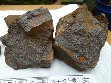
Photo 2. A piece of ironstone seen on the surface of a field at Paddlesworth (scale in mm).
Photo: Joan and Harry Blows
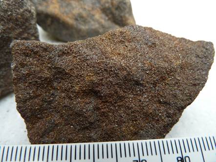
Photo 3. A piece of ironstone seen at Copt Point, Folkestone (scale in mm).
Photo: Joan and Harry Blows
Sources of other construction materials in East Kent
This is a list of locations mentioned in Smart, J.G.O., Bisson, G. and Worssam, B.C. Institute of Geological Sciences (1966).
Sand
Folkestone Formation
“Sandling Junction Sand-pit – p. 89”. (TR 147 371)
Woolwich Formation
“Large sand pit at Shelford – pp. 193, 197” (Barton Down between Sturry and Canterbury TR 161 600).
“North west of the Mental Hospital – p. 193” (in Timpson Wood south of the Sturry road and north of the Littlebourne road, Canterbury TR 165 585)
“South west of White Wall – p. 192” (Denstead Wood south of Dunkirk TR 089 575).
Thanet Formation and Woolwich Formation
“Trenleypark Wood, 500yds west of Swanton Farm – p. 187, 193”, (TR 192 592).
Woolwich Formation and Oldhaven Member
“In an old pit between two roads 500yds south of Fordwich Church – pp.193, 197”. (in Sandpit Wood, off Well Lane, TR 181 593)
Clay
Brick and tile-making using kilns was well-established in the Roman empire. An example of Roman bricks and tiles in East Kent can be seen in the walls of Richborough fort, dating from late C3. Re-used Roman brick can be seen, for example, in the churches of St Martin and St Pancras in Canterbury, and St Mary in Minster. Kilns are located close to clay pits.
Records of Roman clay pits in east Kent are few. Unlike sandstone pits, or even sand pits, the sides of clay pits soon degrade obscuring evidence of their existence. Kent Archaeological Society includes an account of a poorly documented excavation at a Roman Tile Kiln, Bircholt Farm, Brabourne. The quoted approximate grid reference places the site on the Folkestone Formation (sands) but it is close enough to the overlying Gault clay for that to be its likely location. This shows that the Romans were aware of the Gault as a source of clay. The Gault clay outcrops all along the foot of the North Downs in east Kent and so it is reasonable to assume that other pits were excavated.
Gault Clay
A charter granted to Battle Abbey by William the Conqueror conferred ownership of tile kilns at Naccolt in the Royal Manor of Wye, and brickmaking is known there since C11.
Naccolt brickworks (between Hinxhill and Wye) – late C19 – mid-C20 – wire-cut facing bricks and roofing tiles. * ‘Geology of the Country around Canterbury and Folkestone’ Smart, J.G.O., Bisson, G. and Worssam, B.C. Institute of Geological Sciences (1966) p298.
Prior to the construction of the channel Tunnel, an active pit of the Folkestone Brickworks was recorded in the Gault about 100m south west of the current tunnel entrance J.G.O., Bisson, G. and Worssam, B.C. Institute of Geological Sciences (1966) p100, p298. The same source records numerous pits which exposed the Gault but their purpose is not specified.
There is a suggestion that some pits in the Gault were dug to extract the calcium phosphate for fertilizer from the phosphatic nodules found at the base of the clay, but this was found to be uneconomic. Smart, J.G.O., et al (1966), p299.
London Clay
Tyler Hill – extensive industrial site producing roof tiles, floor tiles and pottery. Early-medieval – C19; notable for decorated floor tiles C12-C14. * (Scheduled Monument – Part of the Tyler Hill medieval pottery and tile industry – Historic Environment Record 1426019)
Thanet Formation
Hammill Brickworks – 1927-2008. On the site of the former Woodnesborough Colliery. * ‘Geology of the Country around Ramsgate and Dover’ Shephard-Thorne, E.R. British Geological Survey (1988) p39.
Brickearth
Elham – Clavertigh from at least C16, notably for the construction of Sandgate Castle 1539-40. Elham Valley Brick and Tile, late C19 – 1908; brickearth dug from the west side of the valley at Exted was slurried and piped to the works in Cock Lane. * Elham_Village Walk_Published_Issue 6A5.pdf Elham Historical Society. p39.
Hawkinge – Fernfield Brickworks – late C19 – mid-C20 – hand-made red and multi-coloured sand-faced bricks. * ‘Geology of the Country around Canterbury and Folkestone’ Smart, J.G.O., Bisson, G. and Worssam, B.C. Institute of Geological Sciences (1966) p298.
Nonington and Easole C16 – C20. Old St Alban’s Court, rebuilt substantially in brick in 1558. *Brick Building in Kent: Old St Albans Court, Nonington
Gravel
Flint gravels from river valleys – Alluvium
Great Stour valley – dredged from below groundwater level, such that many workings are now lakes.
Bretts – various sites between Conningbrook and Stodmarsh. Including the Brett works at Sturry producing aggregates such as ‘Durite Spar’ calcined flint.
Little Stour Valley
Seaton, near Wickhambreux
High level flint gravels from river terraces
Chartham Hatch
Trenleypark Wood
Flint gravels from storm beach deposits
Romney Marsh
Nickolls near West Hythe
Greatstone on Sea
Stonar, Sandwich.
Flint gravels from offshore
Flints
Flints for tool making.
Evidence of flints used as cutting tools has been found at sites which pre-date the beginning of the Ice Age 2.6million years ago. Sophisticated shaping of flint into fine blades seems to have developed during the last glaciation sometime between 50,000 and 10,000 years ago and continued until it was superseded by the smelting of metal in the Bronze Age.
Historic Flint Working Sites.
There is possible evidence of a Neolithic flint working site above Elham KCC Historic Environment Record (HER) No. TR 14 SE 20 states
“On two fields on either side of a footpath leading from Elham Station to Acrise, on the flat summit of the high ground beyond the chalk-pits shown on the OS 6″, N.E Toke and J.N.T Vachell found hundreds of Neolithic flakes, scrapers, axes, Lanceheads, borers and large rough celts, also one large celt which showed signs of grinding. No pottery was found but some probably pot-boilers were noted. Vachell’s collection is in Folkestone Museum. There are some 35 flint scrapers and blades in the museum store but without provenance. They are a homogeneous collection bearing a marked similarity to a few scrapers, flakes and cores picked up during fieldwork off two fields flanking the Acrise- Elham footpath at the position indicated by Toke. (Area centred TR 185433). Other recent finds from the general area include a Neolithic axe (gv. TR 14 SE 6) but no evidence of occupation has been noted. (3)”
- Toke, N. E., 1946, A Prehistoric Occupation Site Above Elham, Arch Cant 58 1945 80 (NE Toke) (Article in serial). SKE7950.
- Harrison, E, 1951, Report for the Year Ending 1949, Ibid 63 1950 xlv (Article in serial). SKE7951.
- F1 CFW 02-SEP-63 (OS Card Reference). SKE42396.
- Wardale, C., 1963, Field report for monument TR 14 SE 20 – September, 1963 (Unpublished document). SKE5420.
HER No. TR 14 SE 208 Early Mesolithic flint working site, Tayne Field. Lyminge
In 2012 a large area was excavated on land to the east of the Coach and Horses on Tayne Field by a team from the University of Reading. The initial topsoil strip exposed a scatter of worked flint across the east and south sides of the trench, covering an area of c.200 square metres. Initial examination suggested that the assemblage was typical of the early Mesolithic period. Much of the flint was recovered from later features. In total c. 10-12,000 flints were recovered. Most of this is debitage (85%) and there are a high number of cores compared to finished tools. It is thought that the site was used for manufacturing tools which were then taken elsewhere for use. (1)
<1> Gabor Thomas and Alexandra Knox, 2012, Lyminge Excavations 2012: Interim Report on the University of Reading excavations at Lyminge, Kent (Unpublished document). SKE25101.
Flint as a building material
Large flint nodules are found in walls of domestic buildings, churches and freestanding walls throughout the Chalk outcrop in south and east England.
In the North Downs flints are readily available at the ground surface and originate from the Chalk and Clay-With-Flints. There are few records (or little need) of flint mines on The North Downs (Kent Underground Research Group).
A flint working site was investigated at Court Stairs near Ramsgate, outside the current area. (Kent Archaeological Society)
Coal mining in East Kent
From the middle of the nineteenth century there was speculation that the coalfield which was being successfully worked in the Nord/Pas de Calais would be found to extend beneath the channel to Kent. The presence of coal beneath East Kent was confirmed in 1890 by a borehole at a site near Dover, at depths of 360 metres and 680 metres beneath the surface. Coal-bearing formations of the Upper Carboniferous were proven, lying in a truncated basin located approximately to the east of Canterbury and Folkestone, and south of Hoath and Sandwich.
The first coal mine was started at Shakespeare colliery, Dover in 1896 following the discovery of coal in 1890. This was at the base of Shakespeare Cliff on the site of the original Channel Tunnel workings (the site of the current Samphire Hoe)
The first shaft was halted by flooding and loss of life. Successive shafts were sunk and attempts made to overcome flooding but wasn’t until 1903 that a shaft hit coal and water ingress was controlled helped by improved excavation methods. The colliery was short-lived. It did not provide enough coal to power pumping engines, and the quality of coal was not the best. Production was halted in 1909 and the colliery was finally closed in 1919.
Coal in commercial quantities was dug from four pits, with production starting at Snowdown in 1912, Tilmanstone in 1913, Chislet in 1915 and Betteshanger in 1927. Snowdown was the deepest, reaching a depth of 940metres.
Chislet Colliery was closed in 1969. Tilmanstone closed in 1986, Snowdown in 1987 and Betteshanger in 1989 (Refs. 3 & 4).
Williams, Peter ‘In Black and White’ (2019)
4. Dover Museum https://www.dovermuseum.co.uk/Exhibitions/Coal-Mining-in-Kent/Coal-Mining-in-Kent.aspx
Joan and Harry Blows, Andrew Coleman.
Rev. 6 21/10/2025
