
This section follows the Little Stour northeast to its confluence with the Great Stour. It passes from the upland landscape of the Chalk Downland to the marshes of the River Stour.
The route passes over the boundary between two of the four great geological Eras, the Mesozoic and the Cenozoic, which dates from 66 million years ago. The Mesozoic-Cenozoic boundary is an “unconformity”. This is a gap in the geological sequence which separates rocks of differing ages, usually representing many millions of years, in this case a period from about 72 to 59 million years ago. 65 million years ago was the time of the most recent of the major extinction events, which amongst others saw the end of the non-bird-like Dinosaurs.
The Chalk of the Mesozoic, which had formed the high ground in the Elham Valley, dips below the Cenozoic rocks which comprise fine grained sands with occasional sandy clays. These are weaker than the Chalk and so result in a much more subdued relief – the depth of the valley beyond Bridge reduces noticeably compared with the section upstream. There is therefore less landscape to relate to geology, so this section may be a little light on geology.
The valley makes an abrupt right-angled turn at Bridge as it departs from its brief north westerly course from Barham, back to its north easterly course. According to the local Geological Memoir, (Smart et al., 1966) this change in direction may also mark the position of an ancient “river capture”. River capture occurs when the source of a stream works its way upstream, extending its valley, and intercepts a second stream flowing across its path. The first stream then captures the water of the second stream, diverting the water down its own valley.
Various river capture scenarios, which could account for the abrupt change in direction, are discussed at length in the memoir. One suggestion is that the “Little Stour” (as the Memoir refers to the Nailbourne at Bridge) originally flowed westwards from Bridge, along the valley at the foot of the Chartham Downs, to join the Great Stour at Shalmsford Street. Meanwhile, a headwater of the (current) Little Stour, rising to the north-east of Bridge was cutting back south-westward. It eventually intersected the Nailbourne at Bridge, capturing its waters and diverting the stream north-eastwards along the Little Stour valley. This left the lower part of the original Nailbourne stream flowing west along the foot of the Chartham Downs with a much-diminished water supply, promoting its disappearance.
Apart from explaining the origin of the large, but now dry, valley at the foot of the Chartham Downs, the Memoir also points out that it would account for the otherwise unexplained large accumulation of gravel in the Great Stour at the confluence of the original Nailbourne and Great Stour at Shalmsford Street.
Beyond Bridge, the valley is underlain by the Chalk of the Seaford Formation which is obscured by Alluvium in the base of the valley. As the route approaches Bekesbourne, note the higher ground to the north. This is underlain by the Thanet Formation, part of the Montrose Group, which is the first encounter with the Cenozoic rocks (see Photo 1.) The Thanet Formation dates from about 59 to 56 million years ago and comprises sands, silts and clays.
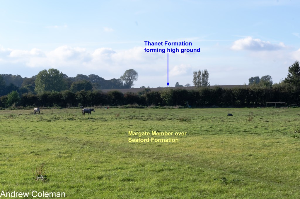
As you approach the railway bridge you can see that the gradient of the slope to the southeast increases in the middle distance (Photo. 2). This increase coincides with mapped boundary of the Seaford Chalk Formation, beneath the floor of the valley, and the overlying Margate Chalk Member which is a locally developed variation of the more extensive Newhaven Formation. The Margate Member typically forms steeper slopes than the Seaford Chalk (Aldiss et al., 2012).

Halfway between the railway bridge at Bekesbourne and Littlebourne, the route passes close to the remains of “Well Chapel” which is hidden in woods on the north side of the valley. The springs here are attributed as the source of the Little Stour, although early accounts name the springs which feed into the lake in Bourne Park, which is further upstream. So, from here on, the route is following the Little Stour valley.
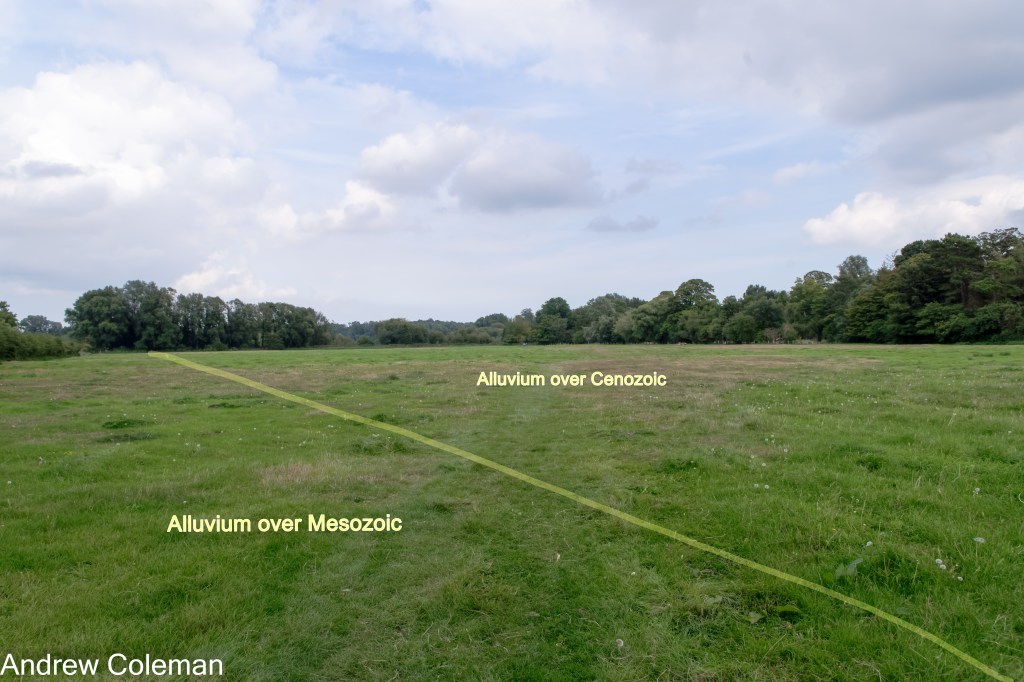
On leaving Wickhambreaux, the north easterly dip has brought the Cenozoic Montrose Group down to the level of the valley floor as the Mesozoic Chalk Group finally dips below the younger rocks north east of Wickhambreaux. There is nothing to see here to indicate the Mesozoic – Cenozoic boundary, which is obscured by Alluvium on the valley floor. The mapped boundary is about halfway along the footpath across the field which begins at the bend on Seaton Road (see Photo 3).
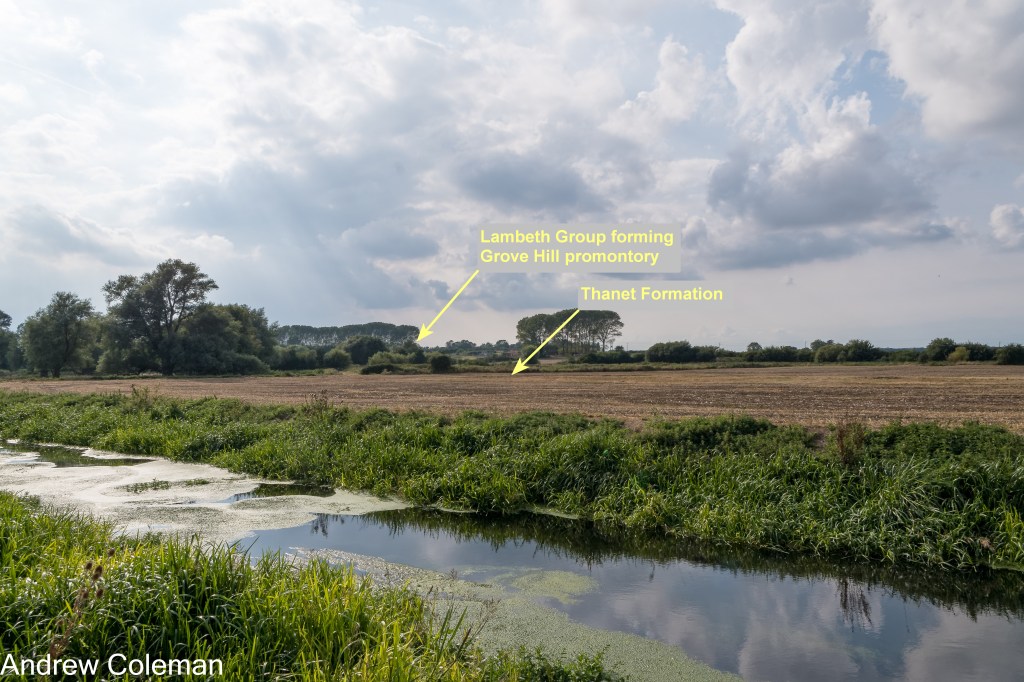
The footpath continues through a wooded area along the river between flooded gravel pits, as indicated on the O. S. maps. The geological map shows this location to be underlain by Alluvium over Thanet Formation (sand). Whilst Alluvium can be a variable deposit, it is essentially a fine grained material so it is a surprise to find gravel workings here. It is possible that the gravel was gained from an un-mapped occurrence of the 2nd River Terrace Deposits beneath the Alluvium. (There is a small inlier of this deposit shown on maps protruding from beneath the alluvium nearby). These workings are at the point where the Wingham and the Little Stour Rivers join. Such confluences often produce accumulations of gravel.
The route emerges from the trees to meet this confluence. The Higher ground which you can sea to the east is an outlier of younger deposits overlying the Thanet Formation which stretches from just north of Wingham to Stourmouth (Photo 4).

The geology here is mapped, in ascending order, as the Lambeth Group – with no individual Formations specified, followed by the Harwich Formation and the London Clay Formation which are both part of the Thames Group.
The ascent into Preston takes you onto the London Clay, the youngest deposit in the sequence. On the way to St Mildred’s Church the route passes through a high wooden gateway into a field with topography that suggests previous excavation (Photo 5). The 1898 O.S. 6 inch map shows gravel workings and Site of Roman Cemetery. The 1938 6 inch map shows the workings less distinctly but includes Site of Roman kiln.
The geology here is mapped as Head over Lambeth Group, but the 2nd River Terrace Deposit (sand and gravel) is mapped immediately to the north and a deposit which the BGS calls “Head 1” (sand and gravel) is shown immediately to the east. So the workings were exploiting the River Terrace gravels, or possibly the “Head 1” deposit, both could be found beneath the “Head”.

After descending from Preston and re-joining the Little Stour, looking north west across the river, you can see a very slight rise which diminishes northwards – the expression of the geology is subtle in these parts. This is the eastern end of Grove Hill which is another outlier of London Clay and Lambeth Group which separates the Little Stour from the Great Stour valleys (Photo 6).
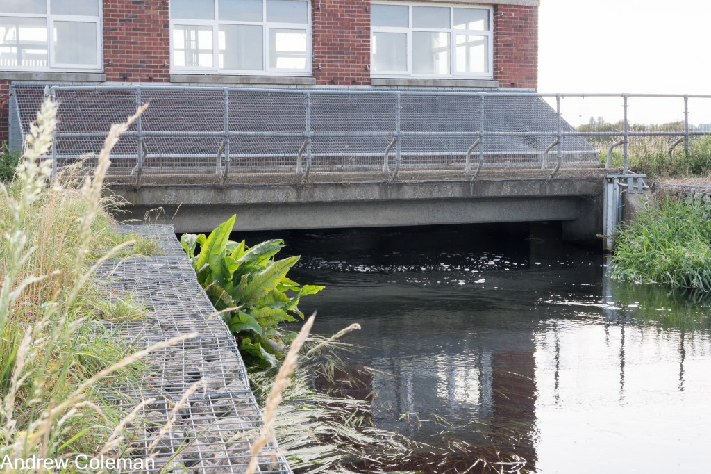
The lower part of the Little Stour valley here has been affected by mining subsidence caused by coal extraction from the Chislet Colliery (now the site of Canterbury Industrial Park near Hersden). As a result, the lower reaches of the Little Stour River and its flood plain are below the level of the Great Stour at high tide. This area would flood if it was not for the pumping station which raises water up to a level which allows it to flow into the Great Stour at Plucks Gutter about 2km downstream. (Thanks to Harry Blows for pointing this out to me.)
You can see this pumping station if you look downstream from where the RSW leaves the Little Stour to climb up to West Stourmouth. You can detour along the river bank to visit it and re-join the route by following the service track up into the village and All Saints Church. The pumps are not continually running, they are triggered by the water levels (Photos 7 and 8).
The marshes to the north west between the Little Stour and the Great Stour are the sites of medieval salt workings (KCC Heritage list).

After descending from West Stourmouth the route passes down onto the low flat lands of the Wantsum Marshes. Looking north east across the marshes, the slope of the Isle of The Isle of Thanet rising from the marsh contrasts with the gentler relief on the south western side (see Photo 9). This slope is the re-emergence of the Chalk caused by a small but steep upward fold parallel to the main Weald – Artois Anticline to the south. The trough in the chalk strata in front of this fold produced the tract of low-lying land which was flooded by rising sea levels at the end of the last glaciation and which formed The Wantsum Channel. The inundation was followed by a slow silting up of the channel, eventually restoring the Isle of Thanet to the mainland.
A deviation: Follow this link for an outline of the sequence of these events leading to The disappearance of the Wantsum Channel.
The geological map indicates the marshes now present in the former channel are underlain by Tidal Flat Deposits. These are, as the name suggests, a marine deposit and their extent indicates of the maximum width of the tidal channel here, shortly after the end of the last Ice Age. The map shows these deposits to be about 3km wide opposite Minster-in-Thanet.

Andrew Coleman
Rev. 02/06/2025
References:
Aldiss, D. T., Farrant, A. R., & Hopson, P. M. (2012). Geological mapping of the Late Cretaceous Chalk Group of southern England: A specialised application of landform interpretation. Proceedings of the Geologists’ Association, 123(5), 728–741. https://doi.org/10.1016/j.pgeola.2012.06.005
Smart, J. G. O., Bisson, G., & Worssam, B. C. (1966). Geology of the Country around Canterbury and Folkestone. Her Majesty’s Stationery Office.
